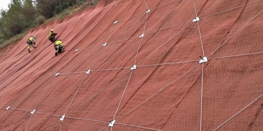
A 10-meter cut on Sumas Mountain exposed a slickensided clay layer that wasn't visible during the preliminary site walk. The developer had already poured footings for a four-building townhouse complex when the first tension cracks appeared at the crest. Abbotsford's unique position, straddling both glacial uplands and the Matsqui flats, means project sites routinely encounter complex stratigraphy: advance-phase glacial till overlying sensitive glaciomarine silts, often with artesian pressures at the interface. A slope stability analysis isn't a checkbox here. It's the difference between a project that holds through a wet November and one that mobilizes into the neighbor's lot. Our team runs Spencer and Morgenstern-Price limit-equilibrium slices on every modeled section, incorporating in-situ permeability data when groundwater response matters, and we cross-reference findings with triaxial consolidated-undrained strengths from undisturbed Shelby tube samples.
A slope that stands today in August may not survive the first atmospheric river in November. The analysis must account for the water that hasn't arrived yet.
Process and scope
Every Abbotsford slope tells a different story depending on which glacial advance deposited the material. The Sumas Drift behaves differently than the Vashon till, and both respond dramatically to the seasonal saturation cycles we get between October and March. A properly executed analysis here starts with high-quality input parameters. We extract undisturbed samples at the critical failure surface depth, run multi-stage CU triaxials to capture the stress path, and model both short-term undrained conditions for construction sequencing and long-term drained conditions for permanent slopes. Pore pressure response during the wet season is the variable that catches most designers off guard; Abbotsford's rainfall intensity regularly exceeds 80 mm in 24 hours during atmospheric river events, and that infiltration front changes everything. Factor-of-safety targets follow the NBCC 2020 and local municipal requirements: 1.5 for long-term static conditions, 1.3 for temporary cuts, and 1.1 minimum for pseudo-static seismic loading under the design earthquake for the Cascadia subduction zone scenario. We deliver both circular and non-circular failure surface searches because the Sumas Mountain colluvium doesn't follow textbook geometry.
Common questions
What slope angle is stable in Abbotsford glacial till?
There is no single answer. Compact Vashon till can stand at 1H:1V temporarily, but weathered Sumas Drift with silt lenses may require 2H:1V or flatter. The analysis must consider the specific material, cut height, groundwater conditions, and whether the slope is temporary or permanent. We run site-specific stability models for every project because the till matrix varies significantly across the city.
How long does a slope stability analysis take?
For a typical single-family lot cut on the Sumas escarpment, the field investigation takes two to three days, and the analysis and report are delivered within ten business days after lab results are complete. Multi-building subdivisions or slopes exceeding 15 meters in height require a longer timeline due to the additional modeling iterations and peer-review requirements.
Do I need a slope stability analysis for a small backyard cut?
If the cut exceeds 1.2 meters in height and is within 3 meters of a property line, the City of Abbotsford typically requires a geotechnical assessment. The Building Department reviews each case, but we recommend an analysis for any cut over 2 meters, even on private property, because the cost of a small rotational failure often exceeds the analysis cost substantially.
What does a slope stability analysis cost in Abbotsford?
The analysis and reporting typically ranges from CA$1,840 for a straightforward single-cut assessment to CA$6,250 for a multi-slope subdivision with seismic deformation modeling. The scope of drilling, laboratory testing, and the number of modeled sections drives the final cost.