Abbotsford sits on a fascinating geological boundary where the Fraser Valley lowlands meet the Sumas Mountain foothills. This transition zone creates unpredictable subsurface conditions that catch many developers off guard—glacial till, alluvial gravels, and occasional peat lenses all within a single site. Electrical resistivity testing cuts through that uncertainty. By measuring how easily current passes through different materials, we map clay beds, sand channels, and perched water tables without ever breaking ground. For projects near the Matsqui Prairie or along the Sumas River corridor, understanding the resistivity profile means knowing exactly where groundwater sits before you dig. The method works exceptionally well in Abbotsford's silty-clay matrix because the contrast between saturated and dry zones reads clearly on a VES curve. Many geotechnical firms skip this step and rely solely on boreholes, but a single boring tells you what's at one point—test pits can supplement surface observations, while resistivity gives you the continuous cross-section between those points.
Electrical resistivity in Abbotsford's glacial terrain maps what boreholes miss: the continuous stratigraphic boundaries and perched water zones that dictate excavation planning.
Local ground factors
Abbotsford's development pattern has pushed steadily southward into former agricultural land around Bradner and Mt. Lehman, areas where the surficial geology map shows complex glaciomarine and glaciofluvial deposits. These soils hold water differently depending on grain size and compaction history, and resistivity is one of the few techniques that can distinguish a water-bearing sand lens from a saturated clay layer—both look similar on a drill log but behave completely differently during excavation dewatering. A project that misidentifies a confined aquifer as a simple perched zone faces sudden inflow during foundation excavation, potential slope instability on cut faces, and regulatory headaches with environmental discharge permits. The resistivity data feeds directly into dewatering system design by identifying the depth, thickness, and lateral continuity of water-bearing units. On sites within Abbotsford's designated floodplain zones, this information becomes critical for both construction sequencing and long-term drainage planning under the city's updated stormwater management bylaws.
Common questions
What depth can a VES survey reach in Abbotsford's soil conditions?
In the silty-clay and glacial till typical of the Abbotsford area, our VES surveys routinely achieve penetration depths of 100 to 150 meters below surface. The actual maximum depth depends on the maximum electrode spacing we can deploy on your site—generally 200 to 300 meters of linear access gives the deepest readings. Clay-rich soils actually help here because they're more conductive, allowing current to penetrate deeper than in dry sandy or gravelly ground.
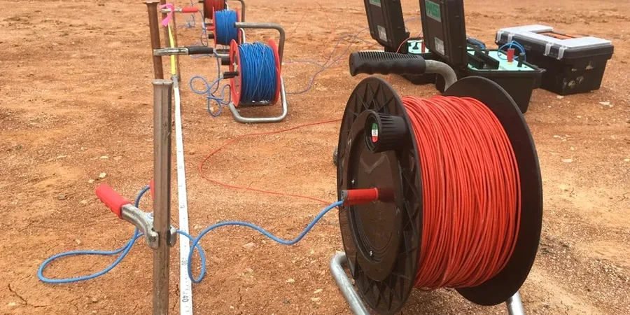
How does electrical resistivity compare to borehole drilling for site investigation?
These methods complement each other rather than compete. A borehole gives you a physical sample at one location—you know exactly what material is at each depth. Resistivity gives you a continuous profile of electrical properties between boreholes, revealing how layers connect laterally. We typically recommend drilling at least one borehole to calibrate the resistivity data, then using VES or ERT lines to extend that calibration across the entire site at a fraction of the cost of additional drilling.
How long does a resistivity survey take on a typical Abbotsford site?
A single VES sounding with full depth penetration takes approximately 45 to 90 minutes depending on the maximum electrode spread. A 2D ERT line of 200 meters with 5-meter electrode spacing typically requires half a day including setup and breakdown. Most Abbotsford residential or small commercial projects can be completed in one field day. Larger multi-line surveys on industrial or agricultural sites may span two to three days.
Can you survey through pavement or concrete?
Standard resistivity surveys require direct electrode contact with soil, so paved surfaces need small holes drilled for electrode placement. We use a rotary hammer to create 1-cm diameter access points through asphalt or concrete, which can be patched afterward. On sites with extensive hardscape, we discuss alternative layouts or complementary methods like ground-penetrating radar that don't require ground contact.
What does electrical resistivity testing cost in Abbotsford?
For a typical Abbotsford project, VES and resistivity surveys range from CA$850 to CA$1,390 depending on the scope, number of soundings, depth requirements, and whether 1D or 2D acquisition is needed. A single VES sounding for residential foundation investigation falls at the lower end, while a multi-line ERT survey with full inversion modeling and interpretive reporting reaches the upper range. We provide a fixed-price quote after reviewing your site plan and project objectives.